Interactive US Map – Create Clickable & Customizable U.S. Maps
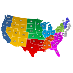
Create engaging Interactive United States Maps in WordPress for free. It's easy to install, simple, and highly customizable.
Interactive US Map ranks #11,099 among WordPress.org plugins with 300+ active installations, is #142 of 939 in the Maps & Location category, a 5/5 rating from 5 reviews, and was last updated Aug 25, 2026. Data from WordPress.org, refreshed twice daily — see methodology.
Next Milestone 400
Unlock Exact Install Count
See the precise estimated active installs for this plugin, calculated from real-time ranking data.
- Exact install estimates within tiers
- Track install growth over time
- Milestone progress predictions
Rank Changes
Downloads Growth
Upgrade to Pro
Unlock 30-day, 90-day, and yearly download history charts with a Pro subscription.
Upgrade NowReviews & Ratings
Security History
Source: WPVulnerabilityNo known vulnerabilities on record for Interactive US Map. Checked 1 month ago.
Track This Plugin
Get detailed analytics, keyword tracking, and position alerts delivered to your inbox.
Start Tracking FreePlugin Details
- Version
- 3.4.8
- Last Updated
- Aug 25, 2026
- Requires WP
- 3.3+
- Tested Up To
- 7.1.2
- PHP Version
- 5.3.3 or higher
- Author
- html5maps
Support & Rating
- Rating
- ★ ★ ★ ★ ★ 5
- Reviews
- 5
- Support Threads
- 0
- Resolved
- 0%
Keywords
Upgrade to Pro
Unlock keyword rankings, search positions, and detailed analytics with a Pro subscription.
Upgrade NowSimilar Plugins









TL;DR
AI summary of the plugin's readmeThis plugin is for WordPress site owners who want to add an interactive map of the United States to their pages, such as for showing branch networks, sales regions, or delivery locations. It solves the problem of presenting regional or location-based information visually by letting visitors click or hover on map regions to see custom info or links.
- Clickable regions
- Responsive and mobile-friendly
- Create unlimited maps
- Tooltips on hover
- SVG based
- Shortcode embedding
- Map customization controls
- Export/import settings via CSV
Frequently Asked Questions
Common questions about Interactive US Map – Create Clickable & Customizable U.S. Maps